


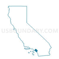
Voting District OCEAN, Orange County, California
About
Outline

Summary
| Unique Area Identifier | 535872 |
| Name | Voting District OCEAN |
| County | Orange County |
| State | California |
| Area (square miles) | 147.03 |
| Land Area (square miles) | 0.03 |
| Water Area (square miles) | 147.00 |
| % of Land Area | 0.02 |
| % of Water Area | 99.98 |
| Latitude of the Internal Point | 33.59284400 |
| Longtitude of the Internal Point | -117.87550200 |
Maps


Graphs
Select a template below for downloading or customizing gragh for Voting District OCEAN, Orange County, California


Neighbors
Neighoring Voting District (by Name) Neighboring Voting District on the Map
- Voting District 20261, Orange County, CA
- Voting District 20266, Orange County, CA
- Voting District 20276, Orange County, CA
- Voting District 20286, Orange County, CA
- Voting District 21131, Orange County, CA
- Voting District 21141, Orange County, CA
- Voting District 21176, Orange County, CA
- Voting District 22391, Orange County, CA
- Voting District 23831, Orange County, CA
- Voting District 50001, Orange County, CA
- Voting District 50006, Orange County, CA
- Voting District 50021, Orange County, CA
- Voting District 50086, Orange County, CA
- Voting District 50211, Orange County, CA
- Voting District 51077, Orange County, CA
- Voting District 51078, Orange County, CA
- Voting District 51081, Orange County, CA
- Voting District 51096, Orange County, CA
- Voting District 53856, Orange County, CA
- Voting District 53859, Orange County, CA
- Voting District OCEAN, Los Angeles County, CA
- Voting District OCEAN, San Diego County, CA
Top 10 Neighboring County Subdivision (by Population) Neighboring County Subdivision on the Map
- Long Beach-Lakewood CCD, Los Angeles County, CA (569,100)
- North Coast CCD, Orange County, CA (366,151)
- South Coast CCD, Orange County, CA (304,548)
- Central Coast CCD, Orange County, CA (246,125)
- Camp Pendleton CCD, San Diego County, CA (37,452)
Top 10 Neighboring Place (by Population) Neighboring Place on the Map
- Huntington Beach city, CA (189,992)
- Newport Beach city, CA (85,186)
- San Clemente city, CA (63,522)
- Dana Point city, CA (33,351)
- Seal Beach city, CA (24,168)
- Laguna Beach city, CA (22,723)
- Sunset Beach CDP, CA (971)
Top 10 Neighboring Elementary School District (by Population) Neighboring Elementary School District on the Map
- Huntington Beach City Elementary School District, CA (82,883)
- Fallbrook Union Elementary School District, CA (60,442)
Top 10 Neighboring Secondary School District (by Population) Neighboring Secondary School District on the Map
- Huntington Beach Union High School District, CA (312,204)
- Fallbrook Union High School District, CA (79,673)
Top 10 Neighboring Unified School District (by Population) Neighboring Unified School District on the Map
- Long Beach Unified School District, CA (510,940)
- Capistrano Unified School District, CA (343,291)
- Newport-Mesa Unified School District, CA (195,345)
- Los Alamitos Unified School District, CA (48,688)
- Laguna Beach Unified School District, CA (28,924)
Top 10 Neighboring State Legislative District Lower Chamber (by Population) Neighboring State Legislative District Lower Chamber on the Map
- Assembly District 70, CA (496,195)
- Assembly District 73, CA (444,315)
- Assembly District 67, CA (429,075)
- Assembly District 54, CA (426,146)
Top 10 Neighboring State Legislative District Upper Chamber (by Population) Neighboring State Legislative District Upper Chamber on the Map
- State Senate District 38, CA (973,002)
- State Senate District 35, CA (899,261)
- State Senate District 27, CA (857,163)
Top 10 Neighboring 111th Congressional District (by Population) Neighboring 111th Congressional District on the Map
- Congressional District 44, CA (844,756)
- Congressional District 49, CA (797,428)
- Congressional District 48, CA (727,833)
- Congressional District 46, CA (648,663)
Top 10 Neighboring Census Tract (by Population) Neighboring Census Tract on the Map
- Census Tract 626.04, Orange County, CA (15,174)
- Census Tract 421.03, Orange County, CA (7,418)
- Census Tract 626.43, Orange County, CA (7,246)
- Census Tract 423.13, Orange County, CA (6,471)
- Census Tract 993.08, Orange County, CA (5,847)
- Census Tract 635, Orange County, CA (5,775)
- Census Tract 421.08, Orange County, CA (5,697)
- Census Tract 422.01, Orange County, CA (5,639)
- Census Tract 994.15, Orange County, CA (5,374)
- Census Tract 992.40, Orange County, CA (5,183)
Top 10 Neighboring 5-Digit ZIP Code Tabulation Area (by Population) Neighboring 5-Digit ZIP Code Tabulation Area on the Map
- 92646, CA (55,224)
- 92648, CA (45,317)
- 92672, CA (34,464)
- 92649, CA (32,463)
- 90803, CA (32,031)
- 92629, CA (25,756)
- 92651, CA (23,881)
- 90740, CA (23,729)
- 92663, CA (21,649)
- 92625, CA (12,478)